Indigenous history and colonisation
Pre-Colonial Adaptation and Evolution: Before European colonization, the land around what is now Sydney was home to the Gadigal people, who had a deep-rooted and dynamic connection to the area. This connection evolved through various climatic changes, including the transition from the Ice Age to a climate resembling today’s conditions. The Gadigal people used the foreshore of Sydney’s harbor as a place for gathering and fishing, as evidenced by archaeological findings of campfire ash and tools.
Contrary to common misconceptions, Indigenous history in the region was not static. Some accounts mistakenly portray the Gadigal people of 1788 as unchanged for thousands of years, but Indigenous culture was, in fact, dynamic and adaptable. While British colonization brought significant hardship and displacement, it is essential to recognize that the Gadigal culture continued to adapt and survive, even under oppressive conditions. This perspective challenges the erasure of Indigenous history, emphasizing resilience rather than disappearance.
Invasion and the First Fleet: The arrival of the First Fleet in 1788 marked the beginning of European settlement in Sydney. Governor Arthur Phillip and the penal colony’s establishment were characterized by an informal, ad-hoc expansion around the harbor. While the legal framework was designed to manage convicts, there was a degree of freedom that allowed settlers, including former convicts, to establish local trades, leading to economic activity concentrated around the docks. However, this growth came at a devastating cost to the Indigenous population, who were displaced through land theft, disease, and violent encounters, leading to a loss of cultural diversity.
Governors Phillip and Macquarie: Governor Phillip initially sought to foster peaceful relations with the local Indigenous population, but efforts largely failed as tensions grew. Later, under the leadership of Governor Lachlan Macquarie in the early 19th century, the focus shifted to urban development. Macquarie played a pivotal role in shaping Sydney’s infrastructure, overseeing the construction of critical public amenities such as hospitals, schools, roads, parks, and gardens. His initiatives laid the foundation for Sydney’s transformation from a penal colony to a burgeoning city.
This overview highlights the complexity of Sydney’s colonial history, marked by Indigenous resilience, colonial expansion, and early urban development.
Colonial port: beginnings to decomissioning
Barangaroo and the Early Trading Port: The area now known as Barangaroo played a vital role in Sydney’s early growth as a trading port. Initially a set of docks, later expanded with finger wharfs to accommodate advances in shipping, it became a hub for local and international trade. By the mid-19th century, numerous factories emerged around the docks to process the vast influx of imports and exports, fostering economic growth. However, while trade brought profits, the workforce mainly comprised newer immigrants who faced unstable employment, often holding multiple jobs within short periods. This economic instability contributed to the decline of the Rocks and nearby areas, as wealthier residents relocated to the emerging suburbs.
Industrialisation and Demographic Shifts: The area’s demographic transformation accelerated in the early 20th century, especially after the appearance of plague-carrying rats around 1910. The Rocks, already seen as a declining area, became further stigmatized, reinforcing its status as a working-class neighborhood dominated by low-income dockworkers. The flight of middle and upper classes to the suburbs left the area economically and socially marginalized.
Redevelopment of Southern Darling Harbour: In the mid-20th century, urban planning in Sydney was largely fragmented, marked by disputes between state and local governments. This lack of coherence, combined with the influence of property developers, resulted in inconsistent urban development. However, by the 1970s and 80s, a more strategic approach began to take shape, driven by globalisation and the aspiration to position Sydney as a “global city.” Redevelopment initiatives, including those at the south end of Darling Harbour, aimed to modernize the city’s infrastructure. Although these projects expanded Sydney’s capacity, the neoliberal planning principles led to designs that sometimes lacked vibrancy and community engagement, leaving parts of the area feeling sparse and disconnected.
Decommissioning of Barangaroo Docks: By the late 20th century, industrial activity began shifting south to Botany Bay, rendering the Barangaroo docks increasingly obsolete. This shift culminated in the official decommissioning of the docks in 2003, marking the end of an era for Sydney’s historic trading port and paving the way for new redevelopment opportunities.
This historical trajectory illustrates the transformation of Sydney’s waterfront from a bustling trading hub to a site of urban redevelopment, reflecting broader economic and social changes in the city’s evolution.
Redevelopment process
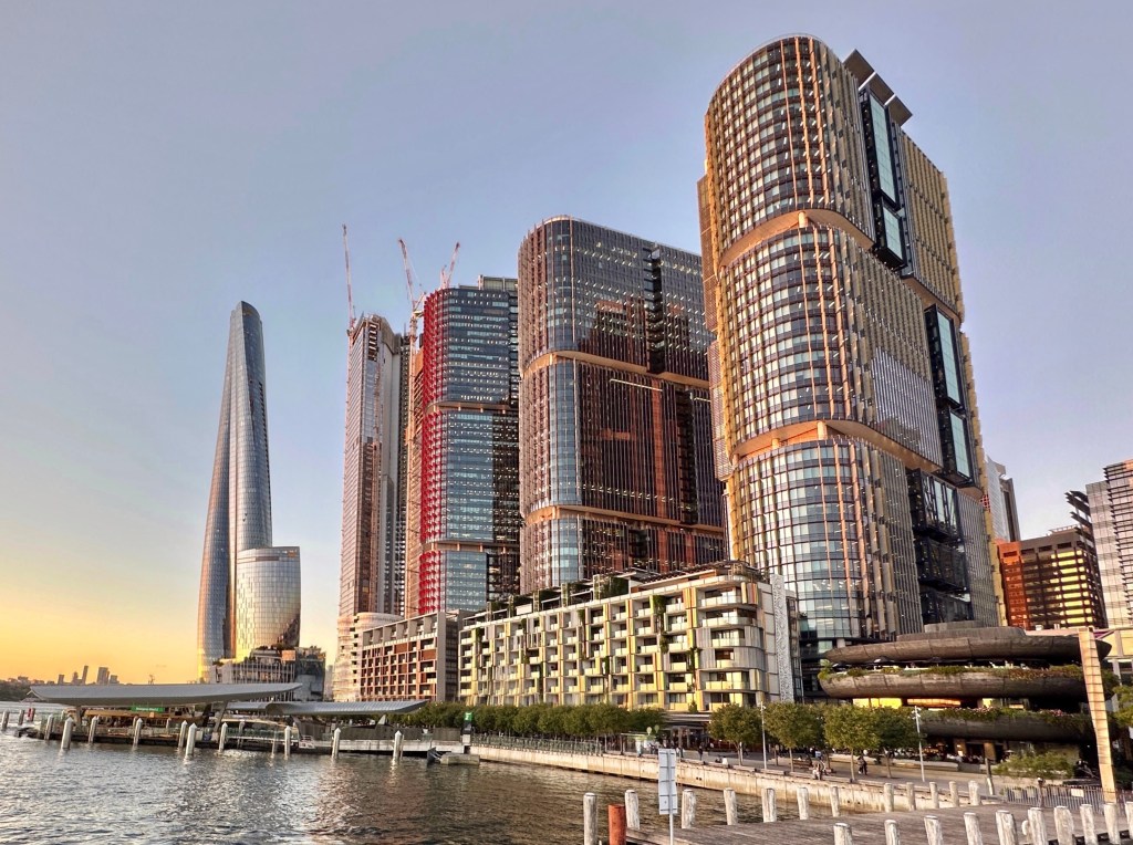
Vision for Renewal To revitalize the defunct docks at Barangaroo and support Sydney’s growth as a global city, the state government envisioned a new financial hub integrated with green, public spaces. In 2004, the East Darling Harbour Taskforce was established to set goals for the redevelopment, which included organizing an international design competition. The competition emphasized urban design, streetscapes, and landscapes, with a commitment to ensuring at least 50% of the area remained public space. The winning proposal, selected in 2006, was a design by Hill Thalis Architecture + Urban Projects, Paul Berkemeier Architect, and Jane Irwin Landscape Architecture, which prioritized public domain connectivity and modular structures. However, the design underwent significant changes, including the addition of a “natural” headland park and coves, sparking debate over the authenticity of these modifications.
2007 Planning Changes and Major Works SEPP Planning for the site was streamlined through the use of the Major Projects SEPP, which classified Barangaroo as a “State Significant Site,” allowing the state government to bypass local council input. This was facilitated by Part 3A of the Environmental Planning and Assessment Act 1979, an amendment aimed at expediting large projects. The first official concept plan was approved in 2007, featuring 399,800 square meters of Gross Floor Area (GFA) and 11 hectares of public space, but with broad and vague development blocks that allowed flexibility in future design decisions.
A series of modifications
Modifications and Evolving Public Domain Over the next 17 years, nine major modifications were made to the original concept plan, shifting the balance between public and private spaces:
- First Modification (2007): Allowed waivers for design competitions if the project met standards of design excellence.
- Second Modification (2009): Increased commercial GFA by 120,000 sqm to accommodate growing demand for office space and address budget constraints, raising concerns about the impact on public accessibility.
- Third Modification (2009): Adjusted the northern end of the development to enhance the “natural” look of the foreshore.
- Fourth Modification (2010): Added a landmark hotel, reduced the width of the southern shoreline public space, and increased building heights, leading to concerns about shrinking public amenities.
- Fifth Modification (2012): Related to building basements but was withdrawn without explanation.
- Sixth Modification (2014): Reduced the commitment to community use space from a minimum of 12,000 sqm to a maximum.
- Seventh Modification (2015): Allowed excavation for basement car parking in Barangaroo South.
- Eighth Modification (2016): Approved the inclusion of Crown Tower, increasing GFA and building height while isolating Hickson Park. Despite some community housing provisions, the increase in private development continued to strain public spaces.
- Ninth Modification (2024, Pending): Focused on Barangaroo Central, proposing a GFA increase to 708,000 sqm, with reductions to Hickson Park and no significant additions to public space.
Governance Shifts and Corporate Interests The governance and management of Barangaroo’s redevelopment also saw changes. The Barangaroo Delivery Authority (BDA), established in 2009, took over planning and development responsibilities, promoting economic growth, sustainability, and infrastructure development. However, critics noted that modifications often catered to corporate interests at the expense of the public domain. For instance, the 2013 legislation change allowed the construction of Crown Tower without substantial public consultation, further diminishing accessible green spaces.
Erosion of Public Domain Since the original concept plan, the total GFA of Barangaroo has increased by 71%, while the provision of public space has not seen equivalent improvements. Although the project has helped transform Sydney’s waterfront, ongoing modifications have raised concerns about the long-term impacts on public accessibility, transparency, and urban vibrancy. The evolution of Barangaroo highlights the complex interplay between public planning and private investment, reflecting broader challenges in urban redevelopment.

Leave a comment